- August 9, 2018
- Data Visualization
This post originally appeared on CityLab.
As today’s cities look for better ways to use the troves of new data at their disposal, augmented reality (AR) offers a new way of bringing this data to life. This technology—which assimilates digital objects and information into the real world via headsets, mobile devices, and other tech tools—has a unique capacity to enliven information and processes via immersive experiences.
AR has captured the public imagination in the form of Pokémon games, Snapchat filters, Minecraft demos, and much more. However, applying this tech to a less sexy task—seamlessly integrating data into everyday experiences—could provide much more concrete value to cities.
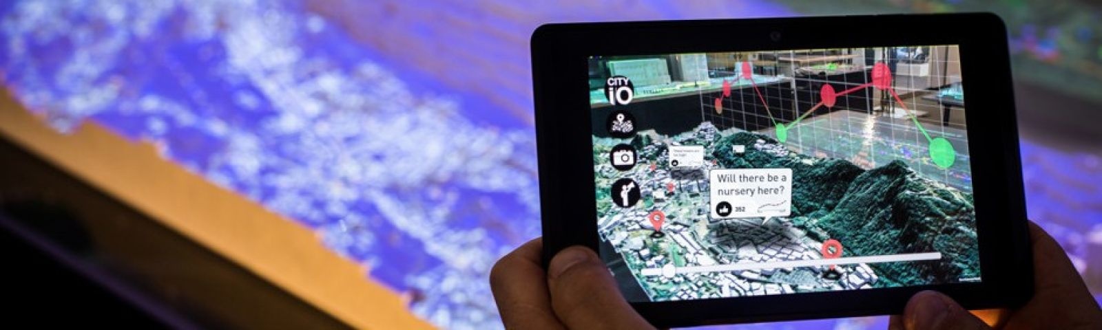
In 2016, as a part of its City Science initiative, the Massachusetts Institute of Technology (MIT) Media Lab collaborated with the City of Hamburg on a project called Finding Places, using optically-tagged LEGO bricks, simulation algorithms, and augmented reality to model potential locations for refugee accommodations. MIT researchers held dozens of community engagement meetings with local leaders and community members, where participants gathered around displays of the city that adjusted in real-time to user interactions, showing key statistics and transformations of urban areas. Locals could move the gridded LEGO bricks around the table to control locations and attributes of accommodations, and visualize the results. Participants identified 160 locations, and the government quickly authorized 44 and constructed ten—compressing a process that can often take years.
Applying this tech to a less sexy task—seamlessly integrating data into everyday experiences—could provide much more concrete value to cities.
Ariel Noyman, a researcher with the City Science project at the MIT Media Lab, has argued that “physical, tangible tools are better for understanding what happens in a city.” AR can vivify once-static data: “If we add an office building, that might be another 700 people leaving in cars and more congestion,” he said. However, there’s a huge difference between hearing this statistic and seeing it played out. “We want people to be able to physically visualize congestion,” he continued.
According to Noyman, “the next big question with AR is how to create collaborations.” While traditional AR—one device and one user—is not inherently collaborative, the Media Lab has explored AR more broadly with tools like the Hamburg display table. As governments push towards a more participatory planning process and engage residents in important decisions, these new technologies offer a more accessible medium for engagement. Not every resident will understand a blueprint of a new subway station, but most will have an opinion when they’re standing in it.
Another MIT collaboration initiated by the city-state of Andorra used AR to do large-scale community engagement, involving a population of 70,000 rather than a handful of community representatives. The Media Lab released an AR mobile app that allowed residents to see and comment upon a 3D model of the city “on their desk at home,” Noyman explained.
This year, both Apple and Google enabled AR as default in their devices, a sign that AR is “going to be something that we use seamlessly more and more,” Noyman said. If the trend continues, these kinds of large-scale civic engagement projects will become more and more feasible, as will other applications in local government. There is the potential for city workers in criminal justice, emergency management, and public works to benefit in new ways from data on places, objects, and people.
Consider the possibilities: Equipped with an AR headset, police officers approaching a building can literally see a 3D floor plan, info on past arrests at the address, and 311 reports about hazardous conditions. First responders can see where residents in distress have plotted their locations and visualize the safest rescue routes informed by real-time disaster data. And public works employees can identify potential hazards at worksites and view relevant repair info, like where a water pipe is located in proximity to other infrastructure. Rather than expending precious time calling up data, workers will simply encounter information in the course of their regular activities.
A number of startups have already created AR tech with these capabilities, if not yet these city applications. Blippar’s AR City mobile app embeds directions as well as info on local restaurants, hotels and more into users’ view of the city landscape. A motorcycle helmet from BMW visualizes route guidance and flashes warnings about roadwork into riders’ vision. White Raven’s AR for connected vehicles displays info on nearby entertainment and retail offers as the driver passes by. It’s only a matter of integrating more existing data into these systems.
Partnerships with institutions like MIT that are already innovating in AR offer cities a way of experimenting with the technology without spending huge sums on products. A number of other institutions including the University of Washington, American University, and Shanghai University have begun exploring government applications of augmented reality, opening possibilities for collaboration with cities. And tech-focused government grants offer additional opportunities for funding. Earlier this year, the City of New Rochelle won $100,000 via the Bloomberg Mayors Challenge to use augmented reality for participatory development, and is now competing for the $5 million grand prize.
But partnerships are not the only way of integrating augmented reality into city operations. Recently Carolyn Bennett of the Boston Planning and Development Department presented the city’s use of AR for urban planning at the ESRI User Conference. Using its existing license with ESRI and the ArcGIS Urban tool, the department was able to visualize the effects of a major construction project in Boston Common, and in response reduced the initial height of the building. The City of Seattle also pursued augmented reality on its own, leveraging Microsoft’s Hololens in a series of public meetings on city zoning plans. The tool allowed residents to visualize potential developments in their neighborhoods, both providing info for meaningful public comment and alleviating unsubstantiated fears of change.
Imaginative officials and vendors can now help transform fieldwork, community engagement, and a number of other areas through augmented reality. To get the most out of these tools however, cities and vendors alike must involve workers and community leaders in designing and deploying these technologies. For AR to work, it must make users’ lives easier and their efforts more effective, rather than merely becoming another flashy piece of technology with little concrete benefit.
Top photo credit MIT Media Lab/Ariel Noyman
 Stephen Goldsmith is the Derek Bok Professor of the Practice of Urban Policy at the Harvard Kennedy School and the
  Chris Bousquet is a PhD student in philosophy at Syracuse University. Prior to that, Chris was a Research Assistant/Writer for Data-Smart City Solutions. Chris holds a bachelor’s degree from Hamilton College.


