
- October 3, 2016
- Infrastructure
It’s five minutes into your morning commute, and whether you’re driving, biking, or walking, you can see them in the distance: orange cones, cordoning off large sections of a busy city street. Within their perimeter are jackhammer-wielding construction crews tearing up the roadway’s surface, snarling traffic for blocks around them.
Sound familiar? For many, the sight is often met with grumbles over a delayed commute or complaints over what seems like never-ending construction. Yet there’s a reason crews are hitting city streets so frequently: under the asphalt lurks a complex maze of water, gas, electric, and telecommunications lines, among other things, that need regular maintenance, repair, and upgrades.
In many cities, this underground infrastructure is decades or even centuries old, and in a constant state of flux. Local governments, along with dozens of private companies, must work together to coordinate these unending street cuts, without any party truly knowing the current layout of what’s underneath the surface at any given time.
Given this underground problem cities face, longer commutes aren’t the only issue for them to contend with, either. According to the American Public Works Association, an underground utility line is hit, on average, every 60 seconds in the United States, costing billions to the national economy. Collectively, these hits, leaks, and other issues impact construction timelines, public and private budgets, and even worker and resident safety.
The underground problem is a complex one without easy solutions. The referee for this process is generally a city’s transportation or infrastructure department, which issues permits for street cuts or emergency repairs. In a perfect world, each city would be able to issue as few permits as possible — yet in the real world, that just doesn’t happen.
One of the only ways a city agency, utility company, or other player can know how and where to start a project is by carving open the street and seeing what’s underneath. If cities wish to reach that perfect-world goal, having a comprehensive, up-to-date map of the underground would help. Yet the technology, complexity, and scope required for such an undertaking prevents most places from making such work a priority.
In order to develop a solution to the underground problem, cross-sector collaboration is not only beneficial, but necessary. It’s also a problem that University + Industry (UI) Labs, a Chicago-based innovation accelerator that officially opened its doors less than two years ago, was built to tackle.
On September 27, 2016, UI Labs officially announced the development of technology for its Underground Infrastructure Mapping (UIM) Platform, which visually captures below-ground assets so that cities, utility companies, and other players may drastically reduce the time and cost required for street projects. The platform, currently in its pilot stage, is being actively deployed in Chicago, using a street in the city’s downtown-located River North neighborhood as the testing grounds for the new technology.
“By improving the accuracy of underground infrastructure information, the platform will prevent inefficient and delayed construction projects, accidents, and interruptions of services to citizens,” said Chicago CIO Brenna Berman, one of the project’s top leaders working with UI Labs, during the project’s announcement.
As UI Labs launches one of its biggest urban infrastructure projects to date, the announcement itself is a milestone for the accelerator. It also signifies its unique operational model’s capability to produce a major technological development, with potentially huge implications for cities worldwide.
Putting Big Problems to the Test
Driven by the City of Chicago, the University of Illinois at Urbana-Champaign, the State of Illinois, and a wide range of academic and corporate partners, UI Labs was designed in part as a research institution in the vein of the old Bell Labs, where the transistor and laser were in part developed. Its design goes beyond a traditional research center role, though, by serving as a forum for cross-sector collaboration.
That forum, which consists of two sub-labs under the UI Labs umbrella, currently has over 250 members that span the industrial and tech sectors, local and state government, academic institutions, research centers, and community organizations. While its structure is complex, the Labs’ goal is straightforward: to develop high-tech, commercially viable solutions that tackle large-scale urban, industrial, and societal challenges through collaboration. These solutions utilize advanced computing, analytics, and Internet of Things (IoT) technologies.
UI Labs, headquartered on Chicago’s Goose Island, was officially launched in February 2014 with the help of a $70 million grant from the U.S. Department of Defense (DOD). That grant helped fund the first sub-lab under the UI Labs title: The Digital Manufacturing and Design Innovation Institute (DMDII), which builds on the region’s industrial strengths to support the digitization of manufacturing technologies. The second of these labs, launched in early 2015, is City Digital, which serves as the home for UI Labs’ smart cities research and development.
This all brings us back to the underground problem: exactly the kind of major urban infrastructure challenge that UI Labs — and specifically, City Digital — was built for. So how does a consortium the size of UI Labs start with such a broad challenge, and finish with the focused development of a specific technology?
“Our job, first and foremost, is to serve as conveners,” said Steve Fifita, City Digital’s Executive Director. “We specialize in identifying problems together at summits and workshops with city stakeholders, corporations, and subject matter experts, and then help determine who’s best equipped to address them.”
During these annually-held summits, City Digital and its partners identify several dozen large-scale problems that current technologies don’t have an answer for. Once these critical areas are identified and prioritized, smaller groups, generally consisting of four to eight partners, emerge to take on these challenges. Within each group, each partner takes on a role unique to their organization.

It’s here where when those innovative cross-sector solutions get developed. An engineering firm and/or university, for example, may take on the R&D needed for a new form of hardware, while a tech firm may design accompanying software or provide the project with computing capacity. From there, City Digital moves forward with local government to help test the viability of what’s being developed via a pilot, using the City of Chicago as its real-world grounds for experimentation.
“Being able to pilot these projects within Chicago’s urban environment is critical to our process,” noted Fifita. “The City really goes above and beyond to ensure that it’s open for such innovative work.”
Real-world experimentation also allows City Digital to help ensure that the technologies its teams develop not only work, but have a demonstrable market value and a viable business model. This feature, combined with corporate and academic expertise, is what makes the City Digital process at UI Labs unique.
Accelerator Process Meets Underground Problem
Within the context of this process, it was the underground data problem that rose to the top in the fall of 2015. David Leopold, City Digital’s Director of Project Management, helped shine a light on just how complex of a task solving the underground problem would be:
“We know the problem, so here’s the question: in Chicago, there are over 100,000 excavations a year by various parties into the street. Every time someone digs into the ground, that’s a theoretical change in the data. How do we then build a 3D underground map for a city that’s not only comprehensive, but able to self-maintain, given all of those routine changes?”
It’s a technological and database management question of huge proportions. It’s also a question that can’t be answered by a single company or organization. To address it, City Digital assembled a team led by global professional services and tech consulting company Accenture, which served as the managing organizer of the project; Chicago-based HBK Engineering, which was the principal designer of the UIM Platform, and the City of Chicago, which consulted with project partners and authorized the UIM project’s pilot. Also involved are local utility company Commonwealth Edison, locally-based data visualization startup City Zenith, mapping software company Esri, technology giant Microsoft, and the University of Illinois at Urbana-Champaign (UIUC). Together, these partners have developed the technologies that constitute the UIM Platform.
What’s Been Built
To provide comprehensive and up-to-date 3D mapping of the underground, the UIM Platform consists of a three-part process that starts with data collection and verification in the field, followed by data digitization and maintenance in a database, and concludes with data visualization on an interface.
So what exactly does all of this look like, and how does it lead to time and cost savings for cities, utility companies and other players? The answer starts with a few digital photos of what’s revealed underneath the pavement during a street cut.
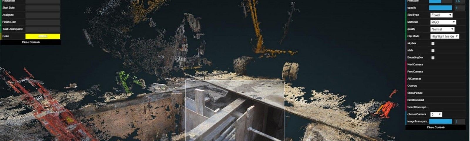
“UIUC began the pilot with taking pictures around an excavation hole,” Leopold said of the data collection process. “Their technology can transform photos into 3D data files of an excavated construction site. Just one site won’t give us much. But many of them, taken together and combined with other forms of data, such as existing GIS data in CAD or other industry formats, can help us create a virtual map of the underground.”
UI Labs’ pilot program takes this principle and puts it into action, as can be seen in the image below. Through mapping thousands of similar data images and points across multiple data sources, a clearer picture of the underground’s pipes, cables, water mains, and other key infrastructure emerges.

So that new data can keep coming into the UIM Platform, the University of Illinois at Urbana-Champaign’s Real-Time and Automated Monitoring and Control Lab (RAAMAC) has also built advanced scanning tools, a data-capture system, and on-site mobile applications. RAAMAC’s data-capturing system in particular allows images from regular digital cameras to get processed into a computer model. Armed with that system and a mobile application, construction or utility crews in the field can then easily add new information to the UIM Platform in real time.
To give planners a more sophisticated three-dimensional view of their underground assets, the UIM Platform’s City Zenith-designed interface provides a detailed visualization with complex data on each bit of material under the streets:
UIM Cityzenith Underground Infrastructure Video from Cityzenith on Vimeo.
That virtual map contains important information that a 2D diagram cannot provide, too.
“When the city and utility companies share their own data of the underground, they often find that they have varying levels of depths listed for various pipes or cables,” noted Leopold. “Outside of a general range, players often don’t know the exact depth that their assets are buried under. This can make coordination extremely difficult.” Looking at a virtual map, of course, helps ameliorate that problem for all players with assets underground.
Behind the project’s interface, UIM Platform partners are also building a database that that will digitize, catalog, and maintain current information on these underground structures. With that information, the City of Chicago — or any city that deploys this technology — will be able to share data with utilities and other organizations that need to understand what is below the surface, while securely limiting what’s viewed to only relevant sections.
With all these technologies combined, what does the UIM Platform team’s end product look like? It is a commercialized Software as a Service (SaaS) model for delivering comprehensive underground mapping to cities, in which data coordination will be facilitated for all public and private utilities operating in a given urban environment.
The UIM Platform also creates an opportunity for cities to completely revamp their models for work permitting and work order management. In Chicago, for example, the city’s process for permitting street cuts is managed by the city’s Office of Underground Coordination (OUC). By having such information beforehand, the UIM Platform may have the ability to reduce construction and development times by potentially more than half. Given projected savings from the technology, the UI Labs team’s solution also includes business model templates for cities to collect revenue.
“Cities are increasingly challenged with the need to manage everything from legacy assets, such as archeological sites, to fiber for high-speed internet,” Fifita said in a press release for the project. “We anticipate that this pilot can be scaled and utilized by cities everywhere.”
Underground Infrastructure Mapping Beyond Chicago

Fifita’s calls for the project to scale worldwide have already received some notice. On September 16, newly-elected London Mayor Sadiq Khan toured UI Labs’ Chicago facilities with a keen eye on the project.
Khan’s introduction to the UIM Platform was part of a larger partnership built between the two cities during an official visit. The “Chicago-London City Data Alliance,” signed by mayors Emanuel and Khan, calls for both cities to establish working groups that will exchange technical knowledge and expertise, expanding economic growth and opportunity in both cities. This includes data-related challenges around city infrastructure and operations.
The UIM Platform was also recognized by the White House during a September announcement for the administration’s annual Smart Cities Week, which promotes the President’s Smart Cities Initiative, launched last year to spur development around smart city technologies. The UIM Platform is not the first Chicago project on the Smart Cities Initiative’s radar, either. The Array of Things, which received federal funding last year, has been described as a collaboratively-developed “fitness tracker for cities.” It consists of hundreds of sensor boxes that will collect and make publicly available data on air quality, noise levels, and traffic, among other areas, to enhance urban and sustainability planning.
Looking Forward
The UIM Platform is a representation of what can be unlocked when varied minds, skills, and willpower from a range of organizations come together to address a shared problem. It’s an approach that’s been gaining steam worldwide — particularly at the city level — but perhaps due to the complex structures, processes, and patience required for success, is not as widely understood as it could be.
The underground problem is just one example of a huge challenge that requires collaboration in order to be effectively addressed. With aging infrastructure, climate change, and more frequent and intense political, economic, and social transformations occurring, the need to adopt collaborative solutions to today’s problems has arguably never been stronger. UI Lab’s work with corporations, universities, and local government is an example of such progress.
And as for the underground problem, UI Labs and Chicago’s local government have shown that collaboration can make the time-consuming and costly task of managing a city’s streets more efficient. In the long term, this may help provide some solace for commuters, too — who would no doubt appreciate a smoother ride to work.
Top photo credit UI Labs
 Sean Thornton is a Program Advisor for the Ash Center's Civic Analytics Network and writer for Data-Smart City Solutions. Based in Chicago and working in partnership with the city's Department of Innovation and Technology, Sean holds joint Masters’ degrees from the University of Chicago, in Public Policy and Social Service Administration. His work has spanned the city's public, philanthropic, and nonprofit sectors.