- Map
- City and County of Los Angeles
- Conduent


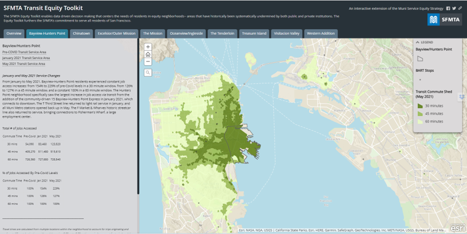
GoLA is a mobile and web app that allows users to plan their trips according to their desired mode of transport (including bike-sharing and travel companies like Lyft and Uber) and how "green" or expensive they want their trip to be. Each trip is associated with a specific cost and number of calories burned. Conduent has created a flexible and easy-to- deploy platform that aggregates data sources and interfaces from various existing and emerging public and private transport providers. The platform intricately processes all the inputs to provide personalized travel suggestions that combine arbitrary modes of transportation including personal (car, walk, bike), shared (ZipCar, bikeshare), ride hailing (Lyft, Uber, etc.) and public (bus, subway, train, etc.) options. When they are ready to take a trip, users will enter their destination and choose if they want to leave now or arrive by a certain time, then click route to see all potential trip options. The program has partnered with many of the public and private transportation modes and companies in the Los Angeles area. Specifically, the app includes private options such as FlitWays, Lyft, Uber, and ZipCar, as well as public options such as LA Metro, Metrolink, motorbike, bicycle, taxis, and parking partner ParkWhiz. Users can also create their own profile based on their transit preferences to save time for future trips. If a user takes a certain trip all the time, like going from home to work, the user can save it by clicking on the heart graphic. Eventually, the app will also begin to learn a user's preferences and begin recommending trip options based on the types of trips the user has taken in the past. For example, if a user often takes trips that include a bike or Lyft, the app will begin to recommend trips that include these transportation options.
DATASETS
Sensors, Census data, data from Zipcar, Lyft, Uber, bikesharing, Google Maps